We may earn money or products from the companies mentioned in this post.
Been working on a map for the City of 10,000 Daggers. So far I’ve got the important buildings, walls, and roads.

There are a few places I haven’t finished them either because I’m still deciding what to do with that part of the map (behind the Necropolis) or because I need to add some buildings to figure out where the roads go (the hilly areas are the main ones). Some of these will be hand drawn like the existing building, but I’m going to try to do most using a brush tool trick I found.
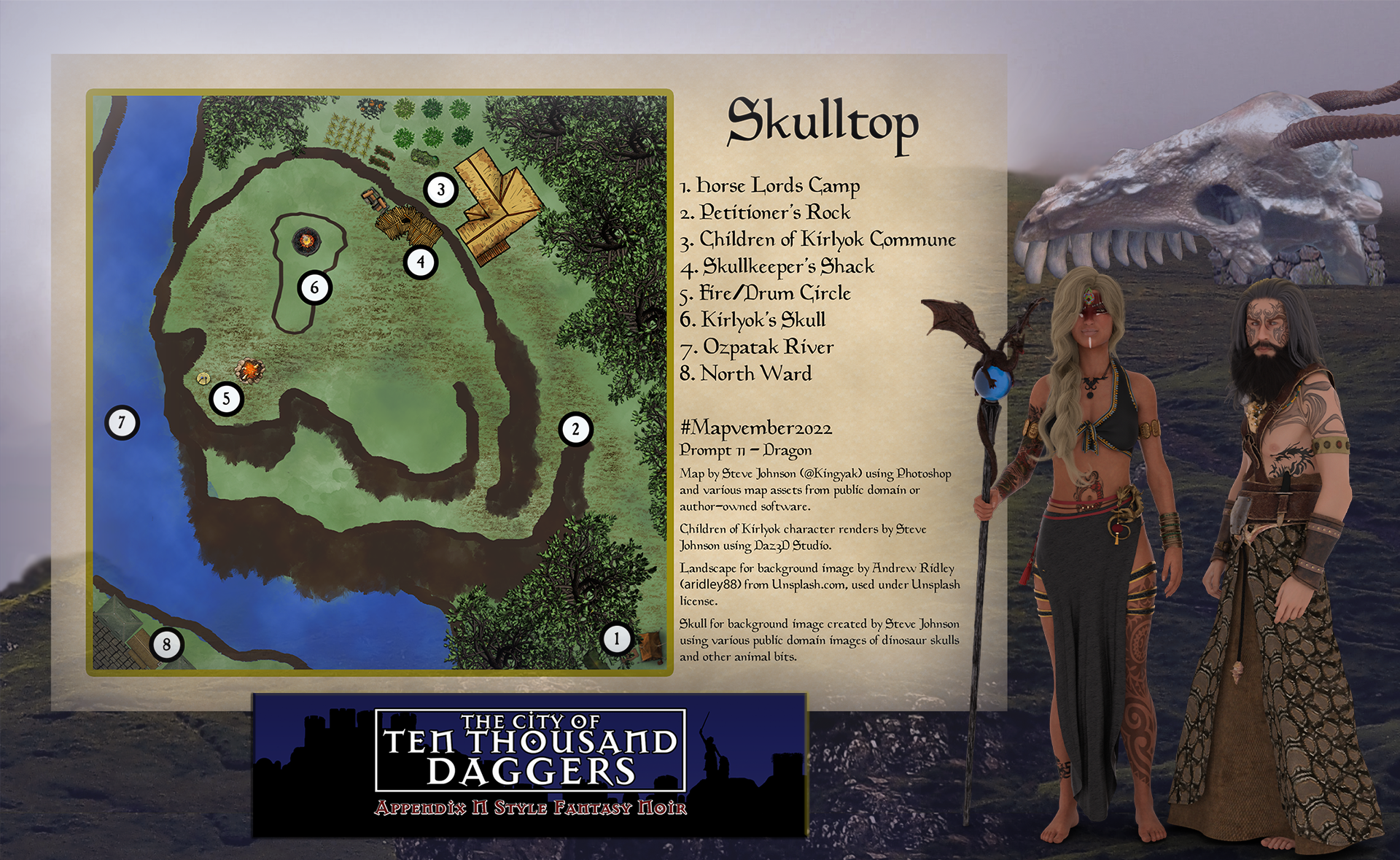
Here’s a quick tour (some of which will make more sense if you’ve been keeping up with the World Anvil page).
- The big open area in the upper left corner is The Necropolis.
- Below the Necropolis is the Imperial Quarter, complete with a legion fortress, imperial mill and grainery (just inside the wall with the canal bordering it), and the Governor’s Palace (Hilltop right on the coast).
- The center spit of land is mostly post-empire construction. Right now I’ve just got the forum and arena drawn in.
- Castle Vargo (founding building and home of Ilka the Faceless) is on the hill kind of in the center of the map. The walls around it mark the boundaries of Old Town. The building down the hill from the castle is Madame Xanthia’s House of Pleasure (which also serves as the home/temple of Kreeshka of the Perplexing Genitals).
- Up near the wall between the Necropolis and Old Town is the hill with the dragon skull where you can have a trippy vision quest.
- The walls built out from Old City are the trade ward. The hill there used to be where dragon tribute was left, but now there’s a huge statue of the Eternal Empress there.
- The little gray building just left of the statue is The Lusty Minotaur.
- The section below that is the dock ward–warehouses and sailor’s taverns and stuff.
- The section between the old and new walls on the right hand part of the map is the caravan district. There’s another legion fort here just down the hill from The Tower of Daggers.
- The slums are in the north around Old Town and the Tower of Daggers.
- The outer walls near the ridge on the lower right (the water there is a major river) will be the stinky part of town (tanneries, fishermen, etc.), with docks in the obvious harbor section and probably some kind of naval base on the island that currently just has a lighthouse.
- Scale is 1 Hex = 120′ if that helps get an idea of the size of the place.