We may earn money or products from the companies mentioned in this post.
Note: This is part 4 of a continuing series (currently up to 9 entries). I’m making an old post public each time I make a new one for patrons (so when Part 10 goes up, Part 5 will go public). If you don’t want to wait, become a patron! You can find out more about Khezvaros, The City of Ten Thousand Daggers, at World Anvil.
This post is going to be an insight into “Why Steve sometimes seemingly does nothing for long amounts of time.” Sometimes it’s because I’m wasting my time watching Netflix or something, but often it’s because I’ve fallen into a rabbit hole of trying to figure out far more detail than is needed about something that doesn’t particularly matter. I should just say “nobody’s going to care” and move on, but I can’t do that, so I spend way too much time trying to find reliable information on something I should probably just make up. I can at least take solace in knowing I’m not alone (you’d be amazed at how much research Leighton and I did for our book of made-up barbecue joints).
So let’s talk about coffee and rainforests.
When I start raising elevations on Coffee Island, I have the same problems I had with Coffee Peninsula: It’s damn near impossible to get more than a tiny area that’s a tropical rainforest at the right elevation. As soon as I raise the land too much, it turns into another kind of forest (usually temperate forest or temperate rainforest). I know places where coffee grows can’t be that rare. I mean, we drink coffee every day, so there have to be a reasonable number of places on earth where it can grow. So let’s start with coffee.
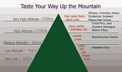
My 3500-6000′ altitude figure from before came from the info box that pops up when you type “what altitude does coffee grow at” (or something similar) into Google, so maybe I need to dig a little deeper. Actually reading more than the first few words that pop up informs me that those altitudes are for Arabica coffee. Robusta coffee, on the other hand, grows and much lower altitudes between 600-2400′. Altitude is still important to how coffee tastes, as shown on the picture below (from this article at Scribblers Coffee, which has more detail if you’re interested):
Next, I need to learn more about rainforests. The area around the equator seems to be generating a few different biomes depending on what I do with the elevation: Tropical Rainforest (which I know works), Tropical Seasonal Forests, Temperate Deciduous Forests, Temperate Rainforests, and Wetlands. I’m guessing that wetlands are swamps and bayous and such, which means lowlands, so I’m going to assume coffee doesn’t grow there.
Typing in “Tropical Seasonal Forest” brings up a Wikipedia page telling me that these are also called “monsoon forests,” which I’m reasonably sure I read during my coffee Googling is where a lot of Asian coffee is grown. Since I think they work and the elevation tweaking isn’t really creating a lot of them anyway, I save the “monsoon regions” map for later (I’ve got a plan!) and move on to the two that really confuse me: The Temperate Forests.
My thinking is that there shouldn’t really be temperate forests in the tropics, in part because the temperate zone is by definition outside of the tropics. Maybe higher elevations can make the temperature milder, but it seems like they’d still be something different than temperate forests in the temperate climate zone. The Temperate Rainforests seem especially confusing, since from what I can tell that’s basically your Pacific Northwest kind of Bigfoot Territory, which just doesn’t scream “tropical” to me.
Full disclosure: The closest I’ve ever been to the tropics is Florida, so I may just not know shit.
Anyway, I think that maybe FMG is calling these forests “temperate” based on rainfall, temperature, elevation, or whatever it uses without necessarily factoring in latitude, so it’s possible they’re actually another kind of forest when they’re near the equator. I decide that I should find out how many different flavors of rainforests there are and see if any of those match. I find this article at Britannica Kids, which seems like exactly the level at which I need someone to explain this to me. The article lists 5 types of rainforest:
- Equatorial Rainforest: This seems to be our baseline “tropical rainforest.”
- Subtropical Rainforest: All indications are that this is a tropical rainforest with slightly more pronounced seasons. When I type it into Wikipedia, it redirects to “Rainforest.” Seems safe to assume this also shows up as “tropical rainforest” on the FMG map.
- Tropical Seasonal Forests, or Monsoon Forests: We’ve already covered these earlier. They seem to be the light yellow-green areas in FMG.
- Montaine, or High-Altitude Rainforests: Wikipedia redirects me to “Cloud Forest.” It kind of seems (from the pictures) that this could be what you get in tropical areas where conditions in temperate areas would give you Bigfoot Country, but that conclusion is based mostly on gut feeling. Also, the Wikipedia page says these are rare, but I’m getting a lot of them when I elevate tropical rainforests, so maybe not.
- Temperate Rainforests: This confirms my suspicions that these happen outside of the tropics.
There’s an “Other Rainforest Habitats” section that lists Riverine Forests (which Wikipedia redirects to “Riparian Forest”; they don’t appear to be promising for coffee) and Mangrove Forests (which are probably what some of the wetlands I keep getting are).
Ok, so maybe I need something more scientifically thorough than Britannica Kids. I head back to Wikipedia and decide I’ll try to decipher the deciduous forests. When I go to the “Deciduous” Wikipedia page and scroll down to “tropical,” it takes me here. A “Dry Broadleaf Forest” doesn’t seem like a promising locale for coffee, but at the bottom of the page there’s a big pile of links where I see “Moist Broadleaf Forest,” which sounds more promising. When I click there, the map looks a lot like the Rainforest map, so a moist tropical broadleaf forest may just be a rainforest. There’s also an entry there for coniferous tropical forest, but there aren’t many of them and Wikipedia doesn’t have much to say about them.
I’ve been saving all the biome maps with a plan to combine them, but fortunately before I start actually doing that I realize it’s probably unnecessary work, since I bet Wikipedia has a combined edition already. Turns out I’m correct. I download the big version for part 1 of my plan. Now I need to find a good coffee map for part 2.

Part 2 of the plan does not go as well as I’d hoped. The plan was to find a map of where coffee grows and superimpose it above the map above to see what biomes it matches up to. Unfortunately, most maps just show the countries that grow coffee, not the specific parts of those countries where the actual growing takes place. The best detailed map I can find is small and not built on the Wikipedia template (and references Canephora, which Google tells me is another name for Robusta):

But at this point it’s a Thing, so I’m going to make it work. I copy the coffee map into a layer over the biome map, lower the opacity until I can see what’s below it, and move and resize it until they more or less match up.

Once the two maps are as aligned as I can get them, I turn the opacity back up on the coffee map, make sure it’s selected, and use “Select Color Range” to select all the red (I have to turn the fuzziness up pretty high to get it all), copy the selection, and paste it as a new layer. I do the same thing with the blue. Now when I turn off the coffee map, I’ve got the coffee-growing areas marked (more or less) on the biomes map:

Now I can zoom in and lower the opacity of the coffee layers to see what biomes are beneath them.

Scrolling around the map, most of the coffee regions are straight-up tropical rainforest, but subtropical rain forests, subtropical dry forests, montane forests, and even several swaths of (presumably high-altitude) grassland also seem to work. There are a couple dots of red in monsoon forests, but I think they’re just there because the maps aren’t exactly aligned; since there are only a few they seem to make more sense in the closely neighboring tropical rainforests. Of course, since these don’t match up to the biomes FMG is giving me, I’m back to my original problem. Luckily, I’ve got a little more knowledge for making some judgement calls now.
If I go back to my FMG map and start raising the height of a tropical rainforest, it turns into a temperate rainforest at about 2,000 feet, so I’m good with assuming that anything that shows up as temperate rainforest and is in the tropical temperature band is really just rainforest (or montane forest at high elevation). As for the deciduous forests, when I check the temperature layer of my map, I see that they’re mostly outside of the “tropical” temperature band (which is very narrow–we’ll get to that in a minute), so they’re probably what they say they are.
So basically I want either tropical or temperate rainforests around my mountains in the tropical temperature band. While accepting temperate rainforests as coffee land makes things a bit easier, the tropical band is really narrow on my map:

This makes me realize my other problem: My world is shaped like Stewie Griffin’s head. Remember when mentioned that if this is an earth-sized world, the map only shows about 1/3 of it? I was talking about east-to-west, but for this to be a sphere, it would also need to apply to north-to-south. If I go into my map and set the scale so that the distance between Khezvaros and the imperial capital is about 1,000 miles, I find that the equator is only ~650 miles from Khezvaros (for comparison Athens Greece, which is at the same latitude, is 2,625 north of the equator). The map itself is only about 3300 miles north-south. If that’s pole to pole, that means the world is only 6600 miles around instead of the 25,000-ish it needs to be to match for longitude to match latitude.
So the map I’m using probably needs to be of just part of the northern hemisphere. Luckily, Fantasy Map Generator has the tools to allow me to make that happen. I’ll get into the details next time.