We may earn money or products from the companies mentioned in this post.
Note: This is part 12 of a continuing series. Up until now, I’ve been making an old post public each time I posted a new installment for Patreon patrons, but the latest post (Part 14) is the final article about the Khezvaros world map. I’ll release one of the remaining installments out into the wild on an unspecified and probably irregular schedule until they’re all outside of the paywall. If you don’t want to wait, become a patron! You can find out more about Khezvaros, The City of Ten Thousand Daggers, at World Anvil.
For those of you reading these as I post them, it’s been exactly one year since I posted. I realize that’s a long time between articles. I ended the last article at a point where I was just about to have to do some kind of tedious work to keep moving and put it off. Then I kind of got sidetracked by/obsessed with 3-D rendering, so hopefully you’ve at least liked the pictures I’ve been making. I’m going to do my best to get the next installment out in (hopefully much) less than a year.
Just to recap, last time around I used a terrain brush set to lay in some mountain icons, which looked good. When I tried to use the same brushes for other terrain features, I ended up with a big mess, so I decided that most other types of terrain (or really, combinations of terrain and climate) would mainly have to be indicated using color. We ended with a screnshot where I’d colored in the Temperate Deciduous Forest biome from my original Fantasy Map Generator map.

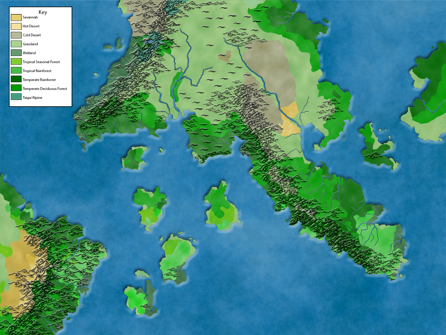
I repeated the same process with all the other biomes, which resulted in this:

This is where the tedious part comes in. Since I’ve made some changes to the landmasses from the original map, I’ve got gaps along most of the coasts, and in some places (like the west coast of the main continent), I’ve got the outline of the old coastlines in a different color. On top of that, the Fantasy map Generator areas are made up of triangles, which is obvious in a few places on full-screen and everywhere when you zoom in. Since each color is a different layer, the borders between them require moving back and forth between layers erasing and painting until the match up the way I want with no gaps. It takes a while, but eventually I end up with something that’s starting to look like a map:

The mountains are kind of getting lost where there are dark colors, so I try adding a layer below them and sort of coloring them in. It works, but now it’s less clear that a lot of the mountains are lushly forested. Also, I’ve completely lost the one tiny bit of Alpine territory on the map. After trying various tricks with changing the opacity and using different blending effects, I give up on coloring the mountains and start looking for other possibilities. I eventually find the Emboss tool and it makes the mountains a little more visible without losing anything. While I’m at it, I emboss the continent to give it a little texture. Lastly, I add some overlay effects (some work, some don’t–there will be some tweaking) to give the map a little life and make a key for the different biomes.
In the end, I end up with a more-or-less finished geographical map:
Now it’s time to start adding the people: cities, countries, roads, that sort of thing. I’ll do that sometime before 2023.